Precision You Can Trust
NABL-Accredited Calibration | Available on Request
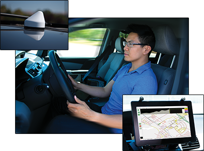
Mobile InterferenceHunter™ MX280007A by Anritsu is a high-performance, multi-emitter interference detection system designed for mobile spectrum clearing and RF interference hunting across urban and rural terrains. Compatible with Anritsu handheld spectrum analyzers, it delivers fast, accurate location of single or multiple interference sources with real-time heat mapping and GPS-aided tracking..
MX280007A Mobile InterferenceHunter™ is an advanced interference detection software application built for RF professionals and security teams. Deployed on a Windows tablet, it turns any GPS-enabled Anritsu handheld spectrum analyzer into a fully functional mobile RF surveillance platform capable of detecting, mapping, and locating interference sources from 9 kHz to 54 GHz.
Unlike traditional fixed-frequency interference tools, MX280007A excels at locating multiple, bursty, or drifting signals, making it ideal for complex urban environments, LTE uplink investigations, and spectrum enforcement. Its post-capture analysis feature allows users to revise parameters without repeating the drive route, making consultations and team-based analysis more efficient.
The heat map visualization generated during Area Scan™ mode refines the emitter's location with each additional reading. Integrated mapping, adjustable signal thresholds, and an intuitive visual breadcrumb trail let single users safely navigate and locate hidden or illegal transmissions.
The system is compatible with Anritsu’s broad suite of spectrum analyzers, including Site Master™, Spectrum Master™, LMR Master™, Cell Master™, BTS Master™, and Remote Spectrum Monitors, requiring no special hardware updates or firmware modifications.
This interference hunting software meets the high operational needs of government regulators, wireless carriers, broadcasters, and public safety teams engaged in RF interference resolution, spectrum compliance, and emergency communications assurance.
Multi-emitter detection – locates multiple interference sources simultaneously
Area Scan™ mode – generates real-time heat maps to pinpoint interference origins
Touchscreen-optimized UI – designed for Windows tablets for ease of use in the field
Squelch control – isolates signals above a user-defined threshold
Max Hold & Min Hold modes – detect both transient and buried signals
Custom terrain sensitivity presets – switch between Dense Urban and Rural profiles
Bread crumb trail mapping – signal strength grows as vehicle nears the source
Spectrum clearing mode – channel power mapping for RF bands
Flexible mapping options – supports Google Maps, OpenStreetMap, and Baidu Maps
No firmware updates required – works with GPS-enabled Anritsu analyzers out of the box
| Parameter | Details |
|---|---|
| Compatible Anritsu Devices | Site Master™, Spectrum Master™, BTS Master™, Cell Master™, LMR Master™, Remote Spectrum Monitors (with GPS) |
| Frequency Support | 9 kHz to 54 GHz (device-dependent) |
| Max Sweep Rate | Up to 24 GHz/s |
| Interface | Windows 7/10/11 tablets or laptops (touchscreen-optimized) |
| Mapping Support | Google Maps, Baidu Maps, OpenStreetMap |
| Emitter Detection | Single and multi-emitter |
| Analysis Modes | Max Hold, Min Hold, Spectrum Clearing, Area Scan |
| Breadcrumb Trails | Real-time drive path showing proximity to source via signal intensity |
| IQ Capture | Post-drive re-analysis supported |
| Power Requirement | Software application (runs on Windows OS device) |
| GPS Integration | Required for mapping and triangulation |