Home ANRITSU | Signal Spectrum Analyzers Handheld InterferenceHunter MA2700A
ANRITSU | Signal Spectrum Analyzers

Handheld InterferenceHunter MA2700A

Handheld InterferenceHunter™ MA2700A by Anritsu is a USB-powered, GPS-enabled, directional interference-hunting tool designed for seamless integration with Anritsu handheld analyzers. Featuring an electronic compass, selectable preamplifier, and compatibility with directional antennas, it streamlines interference mapping with pinpoint vector lines and real-time location data for faster, field-based RF troubleshooting..

  • Detail
  • Special Features
  • Specification

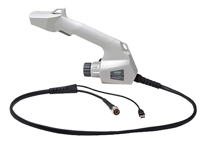
The Anritsu MA2700A Handheld InterferenceHunter™ is designed to accelerate and simplify the process of locating RF interference sources in real-world environments. Built for use with Anritsu’s handheld spectrum analyzers (via firmware-supported models), this accessory enhances Interference Mapping (option 25) by visually plotting vector lines toward interference sources on user-generated maps.

Powered entirely via USB, the MA2700A eliminates the need for batteries, offering reliable field performance with low power consumption (≤0.6W). An internal directional preamplifier boosts weak signals across a wide bandwidth (10 MHz to 6 GHz), with variable gain profiles based on frequency range.

The MA2700A features a high-sensitivity GPS receiver capable of tracking 12 satellites for precise location tagging, and an electronic compass to ensure directional vectors are accurately overlaid on maps. Together, they provide real-time mapping that visually guides technicians to the source of interference.

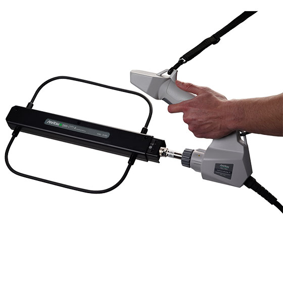
Its ergonomic handle includes a trigger switch that activates logging or toggles the preamplifier, allowing for one-handed use in dynamic environments. The device supports a wide range of directional antennas with Type N connectors and is fully compatible with Anritsu’s low-frequency directional models (with adjustments).

Whether mounted on a tripod or used hand-held, the MA2700A is rugged, accurate, and an indispensable tool for spectrum regulators, wireless operators, broadcasters, and security teams involved in RF monitoring, interference hunting, and compliance enforcement.

  1. Integrated GPS receiver – tracks up to 12 satellites with ±2m location accuracy

  2. Electronic compass – provides directionality with ≤5° accuracy

  3. User-selectable preamplifier – toggle gain modes via handle trigger or instrument control

  4. USB-powered operation – eliminates the need for external batteries

  5. Interference Mapping compatibility – generates directional vector lines on custom maps

  6. Supports directional antennas – works with standard Type N connector antennas

  7. easyMap Tools integration – create, pan, and zoom interactive field coverage maps

  8. Trigger-controlled gain & logging – ergonomic single-hand operation

  9. Mountable for stationary scans – 1/4-20 tripod mount for flexible field deployment

  10. Compact and lightweight – weighs under 1 kg, ideal for extended hand-held use


Parameter Details
Preamplifier Bandwidth 10 MHz to 6 GHz
Gain ≥ 8 dB (10 MHz–2.4 GHz), ≥ 5 dB (2.4–4 GHz), ≥ 3 dB (4–6 GHz)
Power Source USB-powered
Power Consumption 0.6 W (Preamplifier On), 0.5 W (Preamplifier Off)
GPS Satellites Tracked Up to 12
GPS Lock Time Cold: 30s; Warm: 2s (typical)
GPS Accuracy ±2 meters typical
Electronic Compass Accuracy ≤ 5°
Tripod Mount 1/4 - 20 UNC x 7 mm
Size 303 mm x 220 mm x 70 mm (11.9 x 8.7 x 2.76 in)
Weight < 1 kg (2.2 lb)
Antenna Compatibility Directional with Type N female connector, vertical/horizontal use supported
Mapping Tool Compatibility easyMap Tools
System Requirements Anritsu handheld instrument with firmware supporting Option 25